Wednesday, December 26, 2007
AT, Watauga Dam Rd to Watauga Lake Shelter
After returning to where I suspected the trailhead might be, I got out and scouted a bit, and sure enough spotted the white blazes and slightly concealed steps leading from roadway to trail. After returning to my car and gearing up, I was off! There was a relatively mild uphill right out of the box, with a nice switchbacked ascent. Next came a rocky clamber over the ridgecrest, then down the other side, which was a bit more steep. I kept smelling burned wood throughout this entire first section, and figured it was from a recent campfire. When I read the AT book, it told me that the area had burned in the 1970s, but I find it hard to believe that I was still smelling that same burn. Still, I saw no fire rings from which the smoky scent might have emanated. After coming down off the ridge, hit a boring half-mile segment of paved road that led to the dam. Approaching from this direction, one of the first views you get is across the gorge, at the myriad striations exposed on the opposite side. I'm sure this is a geologist's dream. Although it's significance it is admittedly somewhat lost on me, I still find it fascinating to see the aeons-old evidence of the violence that shaped these beautiful mountains.
As I crossed the dam (only AT hikers are allowed to cross the dam, teehee!), I noticed this odd structure. I later found out that it is an emergency spillway. As you can see by the water lines, it has never been challenged, and by the looks of the current levels, probably never will.
On the other side of the dam, the trail ascends again, past a couple of camp sites and along a pleasantly shaded trail to the Watauga Lake AT Shelter.
On the way back toward the dam, I noticed the color of the lake water in a little inlet was eerily similar to the "glacial green" of which I had seen so much in the fjords of Norway. So naturally, I had to try to capture it with a picture! I'm not sure how well I did, but you can at least see the contrast between the leafy green of the trees and the tranquil blue-green of the lake.
Here's the view from atop the dam, looking out across the lake. It was a gorgeous sunny day, yet fairly cool and with a very light breeze ruffling the water. Note that I kindly included the plaque with all the dam's stats (remember you can always click a photo and see it full size) so that I don't have to bore the uninterested by typing them out here :).
This is an edge-on view of the back side of the dam. I found its construction method interesting, given that all of my previous dam experience has been with either huge concrete monstrosities like the Hoover Dam, or ugly utilitarian metal construction like the gates damming Lake Manatee in my home state of Florida.
This was probably the most startling view of all, though. The guidebooks had warned me about it, but nothing really prepared me for it. This is the view from the dam looking away from the lake. Not a drop of water visible anywhere. In fact, even the (surprisingly narrow) pipe that takes the water from the dam to the hydroelectric plant was very difficult to see (don't bother looking for it in this pic, it isn't there). I found this especially puzzling considering the graphic on the sign close to the entrance of the park, which shows a definite ribbon of water extending down from the dam on this side (you can see it here, not my photo).
Despite my puzzlement, I managed to complete my hike. The boring stretch of road between dam and trail was just as boring uphill, with only its cardiovascular benefits to recommend it. As for my usual stats, I found it a little difficult to calculate the length of my hike; according to the AT Guide, it was 3.8 miles. According to another guide, Exploring the Appalachian Trail: Hikes in the Southern Appalachians by Doris Gove, it was 4.4 miles. Finally, my trusty GPS reported that I had walked 4.66 miles. In this case, I'm going with the GPS, because I did do quite a bit of wandering hither and yon on and around the dam.
Stats:
Date: 10/10/07
AT Miles covered: 2.33 (x2 = 4.66)
Altitude gain: roughly 480 feet from dam level to top of beginning ridge.
Sunday, December 2, 2007
US 321 to Horseridge Gap. Or thereabouts.
On this trip, I started once again at the Laurel Falls access trail, this time picking up the AT heading northbound instead of southbound. This was a really tough hike, with its difficulty compounded by the fact that I ran out of energy about ¾ of the way to the “end.” End is a rather nebulous term in itself. My intent had been to hike to where the Hazelwood Hollow trail meets the AT, but never quite figured out where the side trail was. According to my GPS, it seemed to be about 23 feet left of the trail, but when I hit what I thought was the side trail and started hiking in the seemingly appropriate direction, the GPS told me I was getting further away. So I eventually gave up, and just hiked as far as I could manage, and then recorded the spot with a waypoint in the GPS so that I'd know where to end a future hike from the opposite direction.
Not very far up the trail from the Laurel Fork access was a dead doe. I was actually startled when it suddenly dawned to me what was laying right at trailside. Aparently I had approached from upwind, so the only clue was the cloud of flies, which I didn't notice until I was close enough to hear them. I spent a lot of time pondering what had killed the deer, as its neck appeared untouched, and only its belly and chest were ripped open. Even then, a great deal of deer was left, as though it had been taken down by a lone, inexperienced (or just small) predator. I took a few pictures of this on the way back in the hopes of finding someone who could tell me what killed it. In fact, I think this is the only thing I photographed on this outing. Since I try to keep this a relatively family-oriented blog, I don't want to plaster the photos here. They could be quite upsetting. However, if you think you could offer some insight into what killed this poor creature (or if you're just curious and have a strong stomach), the photos can be found here.
The hike itself was a long and somewhat arduous one. There were many, many switchbacks to get up to the ridge overlooking the Laurel Fork gorge. Once there, the trail more or less leveled out for a while, then began to climb again. And again. One piece of trail was so steep, and so absurdly covered with loose gravel and nuts (acorns, I suppose) that had dropped off of the surrounding trees that I thanked my lucky stars I was only carrying a little light daypack. It was as if someone had strewn the embankment with marbles. It was treacherous enough just trying to get my own self up and down (especially down) it safely; I'd hate to have to try it with 40 pounds of crap to throw me off balance.
I saw loads of turkeys near Horseridge Gap. Actually, I heard them long before I saw them. All I heard was their rustling through the leaves, though, so for quite a while I was half holding my breath, hoping it wasn't a bear making all the noise. When they finally came into sight, they were running frantically, a rather comic sight. Eventually they seemed to come to their senses and realize that the best way to escape a scary earthbound mammal like me was to take off into the trees. This they did, almost en masse, and it was actually quite a sight to see. They did seem a little on the scrawny side, though, for it being so close to wintertime. I realize that wild turkeys don't get fattened up in time for Thanksgiving the way the poor critters on farms do, but I would still expect them to be a bit bigger than these, given that the pickins were presumably about to get a lot slimmer.
I was extremely fatigued on the way back. Several times as I made my way down the switchbacks into Laurel Fork gorge, I almost thought I was back in New Mexico, although this wasn't due to delirium. It was a hot day (even starting out), and a searing, dry breeze was blowing up my side of the gorge, carrying a pine-y scent that I distinctly recall from my hikes in NM.
Stats:
Date: 10/8/07
AT Miles covered: 2.0 (x2 = 4)
Other miles covered: 1 (x2 = 2)
Altitude gain: roughly 1,900 feet from access trail to top of highest ridge.
Other notes: Take a lot of water if you're tackling this in the dry months.
Monday, November 12, 2007
Laurel Falls, from a new perspective
After the two access trails re-merge, there is some scrambling to be done over rocks protruding out over the river, and at first I thought I'd lost the trail, as there were no blazes along that section. This was actually how I discovered the upper route of the access trail; thinking the rocks couldn't possibly be trail (and having this thought heartily reinforced by a turned ankle that hurt like the dickens at first), I turned left on to the upper part of the access trail, and followed it all the way back to where it met up with the blazed trail, thereby adding a bit of excess non-AT hiking to my effort.
Once I returned to my point of confusion, I clambered over the rocks (NOT twisting my ankle this time) and eventually found a trail of the wide and level sort to which I'd become accustomed. I imagine when this was a rail route there had been a trestle over the section that is now little more than a rock ledge. A little while after rejoining the wide trail, it becomes AT rather than access trail. Actually, it can be quite easy to miss the point at which the access trail ends and the AT begins, if you're not paying close attention to the blazes. The place where this occurs is marked by an easily missed side trail (which is actually the AT taking off up a mountainside) and a change in blazes, but the trail is so wide and easy to follow, I noticed neither when I first passed through. I made a point of locating the merge on the way back, though, as it was my intent to come back another day and use the access trail to reach the section of AT that heads away from Laurel Falls.
After a couple of river crossings and some nice damp rhododendron/forest hiking (including the unremarkable Waycaster Spring right at trailside), the trail ascends a section where the rocky substrate is often exposed. Trail bed there ranges from tangly exposed roots to pebbly scrabble to open swaths of rock. Near the high point there is a bit of a view:
though I suspect this view might be a bit more striking in wintertime, given that you might actually be able to see the river bed of the Laurel Fork through leafless trees. Still, it was pretty enough when I was there, while the first hints of autumn color were beginning to assert themselves at random intervals.
After descending over more pebbly and rocky terrain, the trail makes another traverse of rocks overhanging the river, though this one is considerably larger and better marked. Still, be prepared for a bit of four-limbed clambering, especially if you're wearing a heavy pack. After that little rough patch, the trail again becomes easily passable, and it's only another two tenths of a mile or so to the falls. Lovely, aren't they?
Admittedly, the wide-angle view detracts a bit, making it look almost vertiginous, to my eye. The last time I had been here, I had approached from the other direction, and had been there no more than a minute before a huge group of 20 or more high school age boys approached, disrobed, and waded into the scene. This quickly spoiled our enjoyment of the natural beauty, and also put the kibosh on our (Jeff was with me) plans to skinny dip a bit. Instead, we waded upstream a bit, put the noisy crows out of earshot, and got a little sun by ourselves. Here's the view downstream, toward where we finally wound up trying to make the best of our rudely interrupted trip.
Not quite so picturesque, but...c'est la vie. I should note here that that group of boys, and their companion group of girls (who arrived perhaps a half hour later) were actually, technically, operating outside of the law. You see, this falls is located within the Pond Mountain Wilderness, and in said Wilderness area, hiking groups are limited to 10 in number in order to reduce impact. Doesn't seem likely that the noisy youngsters in question would have read that part of the sign, though.
At any rate, although I did not continue further along the AT from this point, I can tell you from previous experience that it next takes a long, steep climb over very tall stone "steps." I was in no mood to repeat that experience, so after nibbling on some snacks and staring at the fall for a bit (and being joined by a small family), I departed back the way I came. I also took the shorter high road of the access trail on my way back, and so unfortunately missed my photo op for Buckled Rock, since I figured, on the way to the falls, that I'd stop for a photo on the way back. Silly me.
Stats:
Date: 10/5/07
AT Miles covered: 3.0
Other miles covered: 2.?
Altitude gain: roughly 250 from access trail to top of ridge.
Time: no clue. I'm really bad about this :)
Other notes: probably the easier of the two approaches to the falls, though a bit longer.
Thursday, October 18, 2007
A bit of a rest, and then a fumble
I braved a narrow, winding, unpaved Forest Road 230, and had to yield to a convoy of dumptrucks before I found its intersection with the older Forest Road. The older Forest Road (235, if you're curious) was, as I expected, gated near its intersection with 230. There was ample room to park a car or two there, so I pulled off and gathered up my gear. There was a cute, tinkly little stream running along 230 here, which I had to cross to walk up 235. Nothing worth going out of your way for, but I suppose if you're in the neighborhood...nah, don't bother, even then.
After one or two tenths of a mile, the graveled and graded portion of 235 peters out into a little open field. Beyond that point, the old roadtrack continues, but as one might expect of such a disused thoroughfare, gets progressively more difficult to follow as it goes. At one point I found myself in what looked to be someone's back 40, where an old, old barn or shed stored some very modern-looking building supplies. Deciding that I had somehow managed to leave the road I was trying to follow, I backtracked a bit, and sure enough saw, from this different angle, the roadway I sought. So I continued along it until I finally ran up against a large rockslide that had covered it, probably many, many years ago, judging by the moss growth over the rocks. Feeling discouraged, and not having seen any sign of the AT's friendly white blazes, I decided to give up rather than attempt to cross the rocky, slippery obstacle. I had probably covered roughly five or six tenths of a mile at that point (I had not yet started using a GPS on my hikes), and my foot was still not entirely pleased with me, so I turned around and hacked my way back to the car.
When I got home I looked to the interweb to try to find out what had gone wrong. Via a combination of Google Maps' satellite photos and a slightly closer measurement of my Atlas's depiction, I determined that I likely gave up just one or two tenths of a mile too soon. On the upside, even if I had been able to safely cross the rock fall, it probably would not have made my foot any happier to then continue on and hike the AT section I originally had planned.
So it was back to the drawing board, trying to find more easily accessible segments, and also another day off to let my injury heal.
Stats:
Date: 10/1/07
AT Miles covered: 0 :(
Other miles covered: 1-ish
Altitude gain: unknown feet
Time: too long, due to bushwhacking and such
Other notes: don't bother trying to retrace this route.
Tuesday, October 16, 2007
AT, Carver's Gap to Cloudland Hotel Site
It was along this stretch that I began to notice just how different each of the AT segments I had hiked actually were. The first one I had experienced was just a little jaunt I took out of Nolichucky Gorge Campground, back when I was staying there and trying to find a place to live in this area. It was narrow, almost all rock, and with a steep dropoff to one side and a steep incline on the other. I later came to learn that it had actually been carved from the mountainside by jackhammers.
The next section I tackled was right after I arrived, while my friend Jeff (who so incredibly kindly helped us move) was still in town, and wanted to see a waterfall. We found one called Laurel Fork, and it just so happened that to reach it we needed to traverse a bit of AT through the Pond Mountain Wilderness. That section was partly rhododendron-filled forest, and partly rocky gorge, with some interesting geologic features.
The following two segments are the ones I've just posted about (here and here), and they definitely had different characteristics. Then I reach this next segment, and it is, once again, totally different. I mean, sure, they've all involved trees, ferns, rocks and fungi, but that's pretty much where the similarities end.
This segment took me back to my favored uphill-then-down pattern, although honestly, I could probably have done this one either way, happily, as the grades are almost all very gentle. The primary exception was the side trail up to the shelter, but even that was blessedly short, and so quite tolerable.
It started out in a sparsely wooded area, which struck me as being surprisingly level. Sure enough, someone else, long ago, had thought it a nicely level area as well, because I soon happened upon this fallen chimney right beside the trail:
I traveled a little further on through these sparse woods, and then began my ascent of Roan Mountain via an old carriage road. As mentioned, this made for a very gentle ascent, although switchbacks are sometimes a bit maddening to me. Back and forth, back and forth, it seems like I'm covering the same ground over and over, doing something that would be much more expediently accomplished by a more direct route. Of course, that would also make for a hellacious climb in this case, so I just settled in for a nice, calm walk through the woods. And what woods they were! This section was very heavy on the evergreens, and on many occasions the piney scents that filled the air took me back to a time when I would wander through densely-packed Christmas tree lots in Chicago, just to smell the wonderful aroma.
I knew I was nearing the top when I encountered this still-standing fireplace and chimney, labeled in my AT book as "old cabin site." Actually, when stood in front of this thing and turned in a 360, I could hardly believe there had ever been room for an entire cabin here. Of course, cabins were often quite small in those days, and the surrounding flora has probably had something close to 140 years to recuperate.
After finding myself once again at the Cloudland Hotel Site (and NOT having to pay the $3 parking fee! See what being willing to walk a bit can do for the wallet?), I availed myself of the facilities, and then began my return trek. Interestingly, on my way back, I noticed something I had not seen on the way up; this bunch of old cans and bottles:
It was probably 20 feet or so below the trail, and I did not want to leave the trail in order to investigate further. Still, for some reason, finding things like this excites me more than almost anything else I do when exploring. Signs of previous human habitation, especially ones which may be decades or even century-plus old, are among my favorite finds. Judging by the design of the bottle (since I'm as yet unfamiliar with the decay rates for cans), I'd say this is a genuinely old collection. The bottle didn't look like anything you'd find on modern store shelves (the glass was much too thick, for one thing). Of course, I had to wander off wanting for the details about my find, but perhaps someday I'll be the one examining them and explaining them to others. All part of my master plan...
But for now, back to the details of the hike! On my way up, I had passed by the side trail to the Roan High Knob shelter. I had made the mistake of wasting energy on the side trail to a spring on my last hike, so I decided that in the future I would do side trails on my return trip, just to make sure that I feel completely up to them. Since I still had plenty of energy (and had only downward to travel) this time, I went ahead and scrambled up to this shelter. The story here is that this is the highest shelter on the entire AT (6,285 feet), and was originally built as a fire warden's cabin back in 1933. It was built by the CCC, and used by the warden who manned a nearby tower (which was dismantled in 1940). It was abandoned for at least 20 years before being renovated in 1980 (by the Cherokee National Forest and a Boy Scout Troop) for use as an AT shelter. It was renovated again in 2003 by TEHC. Visiting this shelter was special not only because it was the highest on the AT, but also because it was my first AT shelter ever! I know, not too many people can get excited about such petty things, but humour me, OK?
After my little side jaunt, most of the rest of my hike was easy, gentle downhill. There are a few sections of the old road grade that have gotten narrow, rocky, or otherwise difficult, but for the most part it's some of the easiest uphill/downhill I've encountered on the AT. Near the bottom of the switchbacks I noticed this colorful arrangement of moss and other little plants growing on a rocky outcrop, and couldn't resist the urge to snap a photo of it. I really like the variety, as well as the artful way in which nature has arranged them all. :)
Stats:
Date: 9/24/07
AT Miles covered: 1.9 (x2; out-and-back = 3.8)
Altitude gain:773 feet (including side trail)
Time: no clue
Other notes: Started out the day with pain in left foot believed to be a cramp. Pain did not abate, and later self-diagnosed with peroneal insertional tendonitis. Ouch.
Land of Clouds
This wasn't "just" fog. As I was driving to the site it was very evident that I was ascending into the clouds. Watching them roll past never ceases to fascinate me, but I knew I had to get on with my hike before my energy ebbed, as I was going to have a nasty descent, followed by an even nastier ascent.
The top part of the trail was beautiful, and much of it looked similar to this. Rocky trail, with either trees like these, or bushy evergreens all around. Moss was everywhere, and on this particular day, everything was drippy. It wasn't really raining, it was just a matter of condensation from the clouds gathering on every limb and leaf. I actually recall thinking how, closer to dark, or on the right day (such as Halloween) this scene might even appear spooky. So, if you're looking for a creepy place to go come the end of the month, keep this one in mind. Of course, you can't park here after the parking area closes (and there is a $3 fee to park here when it's open), but there are other ways to reach this place, as you'll learn in an upcoming post.
The photo below is just a really neat-looking moss-mottled exposed tree root. I imagine it might look even cooler in black and white, but I haven't gotten around to converting it yet. The splash of red at the top left is undoubtedly better in color, though.
So, about the hike itself...essentially, it is down, down, down, and then a wee bit of up to come back up to the summit of Beartown Mountain. There is one very wide, pine needle-carpeted area at Ash Gap that is clearly used by AT backpackers for camping. There is also a blue-blazed trail there that leads to a spring, but the spring wasn't all that exciting to look at, so I'll spare you the photo. What was exciting to look at, for me, was a huge bird of prey I rousted on my way down to the spring. It was so silent about gliding from limb to limb that I never heard it at all. It was by sheer luck that I happened to glimpse its movement out of the corner of my eye. I never got close enough that I could actually identify it, but my guess, from what I could see of the pattern on its wings, was that it was a hawk of some sort. Perhaps red-tailed.
After visiting the spring I returned to the trail and continued on to Beartown Mountain. Right near the summit I encountered a fellow dayhiker and his faithful companion, a cute fuzzy puppy. Probably a German Shepherd mix of some sort, very alert and energetic. We passed with a friendly hello, and shortly thereafter I saw that I'd passed that way before, so I could turn around, happy that I had completed another tiny segment of AT.
Then the real work began. Or at least, it began once I re-crossed Ash Gap. The ascent from there back up to the top of Roan Mountain was steep, and I had run myself very nearly out of metaphorical gas. So, I did what I always do when I wind up with my energy ebbing and a hard climb ahead of me: put one foot in front of the other as fast as I could. Which is to say, not very fast. Still, as long as I'm moving forward, I know I'll eventually reach my goal, and sure enough, I eventually re-emerged from the woods, which had grown slightly less spooky as the sun warmed the clouds away. Back at the actual grassy knob where the Cloudland Hotel had been, I photographed the board that told about that fascinating venue.
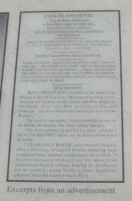
Since it was located on the Tennessee/North Carolina state line, and since, during its years of operation, North Carolina had been a dry state while Tennessee was not, there was a line painted down the center of the dining hall. On the Tennessee side of the line, drinking was of course permitted. On the North Carolina side, it is rumoured that certain members of the North Carolina constabulary liked to hang out, just waiting for an inebriated patron to cross the line with a drink in his hand. Ah, the good old days. Here's an excerpt from the informational board at the hotel site, showing an advertisement for the venerated inn. I found it interesting, and hopefully you will too. Remember that you can click on it to view a larger version. Some of the claims seem a bit of a stretch...but that's all part of it's charm. ;)
Stats:
Date: 9/21/07
AT Miles covered: 1.2 (x2; out-and-back = 2.4)
Altitude gain: 810 feet
Time: no clue
Other notes: $3 parking fee
Friday, October 12, 2007
Trying Out Trekking Poles
Yes, I'm still "just" a dayhiker, carrying a light little pack. And yes, I'm really only 32 years old, so my knees aren't shot yet. But man, have they made a difference! Essentially, they are 4wd for my hiking. At first I couldn't stand to use them on the uphills, so I just strapped them onto my pack for long climbs. But oh, what a change they made in my downhills! I feel as swift and sure-footed as a billygoat. OK, make that a nanny goat. Some stubborn, cloven-hooved critter, anyway.
In truth, I probably look far more like a truncated giraffe as I make my way down the trail, as my "forelegs," being my arms equipped with the poles, are twice as long as my "hind" legs. Appearances be damned, though, as I've long had the motto, "if it works, do it!" This goes double out on the trail, where I hardly see anyone anyway, and anyone I do see has likely seen far more bizarre things than I can muster.
On my last couple of hikes, I've worked up to using them on the majority of my uphills as well. Now I can feel not only the muscles in my shoulder and neck having growing pains, but also my forearms, wrists and biceps. Woohoo! After a recent near-blister incident, I've also repurposed my cycling gloves into hiking gloves, and they work beautifully. The gel padding on the heel of my hand is just what I needed for the downhills, where I turn the poles around and lean on them, instead of trying to use them at the more awkward angle of a pistol grip. This, too, undoubtedly looks weird, but, see motto above.
The first time I took these out for a spin was on the section of the AT between Hughes Gap and the summit of Beartown Mountain. As mentioned, I quickly tired of hassling with them when climbing up the steep ascent. Near the summit was a side trail to an overlook, with some absolutely stunning views. This is only a tiny slice of the vista, but hopefully the seemingly endless layers of mountains in the distance will help you understand just how thrilling a place this was to be.
I met three other hikers this day, and all were backpacking. Didn't stop to query whether or not they were genuine thru-hikers, though they didn't look quite scruffy enough to be such. This was a very challenging climb. In fact, one source, which may be viewed here (search for "possibly the"), believes it to be the most strenuous climb in the entire AT, with the trail climbing over 800 feet per mile. Truthfully, the citation in that link covers the AT all the way up to the Cloudland Hotel site, and I think the segment between where I stopped this day and the Cloudland site is even more steep. I later did that remaining section, from Bear Mountain on up to Cloudland, in reverse; down first, then up. A very bad plan for someone like me, who has most of their energy early in the day. However, to hike the entire AT, I'm sure I will run into this more than just this once, so I suppose I'd better get used to it (or at least resign myself to it) sooner rather than later. But more on that hike later (hopefully).
On the way back down I collected quite a few buckeyes. I'm not sure why, as I was pretty sure about what they were, having eaten the eponymous candy many times. And of course, having had Ohioan parentage, I already knew that buckeyes were "just useless nuts." :) I guess I hoped they were something more useful, like chestnuts. If there's one thing of which I cannot be accused, it is being a botanist. Not even an amateur one. I can tell the difference between a pine tree and a birch, but that's about the extent of my knowledge. Although if I ever manage to drag myself out of bed in time to go hiking with the Old Timers again, that may change a little, as Bill was quite instructive about trailside plants (it was via his tutelage that I came to identify the rattlesnake plantain in this earlier entry).
Stats:
Date: 9/19/07
Miles covered: 1.4 (x2; out-and-back = 2.8)
Altitude gain:1,441 feet
Time: no clue
Other notes: Filled up with gas on the way home for $2.50 per gallon